Why European Forecasts Are Generally More Accurate0:39
Joaquin strengthened into a Category 1 hurricane Wednesday. On that, the meteorologists agree.
But the precarious path that the storm will take in the coming days — belting the East Coast or straying out to sea — remains a point of contention.
The American forecast model predicts Joaquin will veer northwestward, ramming into Virginia, Maryland or North Carolina this weekend. The European forecast model suggests Joaquin will avoid the East Coast entirely. And the National Hurricane Center forecast offers somewhat of a compromise between the two.
Joaquin — the third hurricane of the 2015 Atlantic season — is packing sustained winds of 85 mph as it lurks about 190 miles east of the Bahamas, according to the National Weather Service. It's expected to produce up to two feet of rain over certain areas of the islands.
Regardless of whether the hurricane makes landfall in the U.S., which some forecasters believe could happen in the Mid-Atlantic region by Saturday night or Sunday, a huge swath of the East Coast is bracing for heavy rain and flooding this week.
"It could be a significant situation," said Brian Fortier, senior meteorologist at The Weather Channel. "Everyone along the Northeast coast, right up to New England, should keep a close eye on the forecasts."
A hurricane warning had been issued for Joaquin earlier Wednesday.
The National Weather Service said these warnings are typically alerted 36 hours before "conditions that make outside preparations difficult or dangerous," meaning that "preparations to protect life and property should be rushed to completion."
The storm is predicted to move southwest before swinging northwards, but that's where the agreement between meteorologists ends.
Some experts say the center of the storm will stay offshore; others predict it will make landfall, likely hitting North Carolina or Virginia this weekend.
"If there's anywhere in this country that could take a Category 1 hit, it would be eastern North Carolina," NBC News meteorologist Bill Karins said on MSNBC Wednesday morning.
If Joaquin does make landfall, the mid-Atlantic would face high winds — possibly as strong as 100 mph — and torrential rains.
This Weather Channel graphic shows potential paths of the storm based on different forecast models. The Weather Channel
However, even if the hurricane does not make landfall, its resultant rains looked certain to drench most of the Eastern Seaboard through the latter week and weekend, according to The Weather Channel.
Before Joaquin potentially arrives on the scene, an area from Maine to North Carolina was set for a separate round of rainfall that had already started overnight Tuesday into Wednesday in some areas.
New York Gov. Andrew Cuomo warned residents to prepare for rain and potential flooding.
Time for a Swim as Virginia Clobbered by Flash Floods0:40
"Our state has seen the damage that extreme weather can cause time and time again — and I am urging New Yorkers take precautions for more heavy storms in the coming days," he said in a statement.
Public Service Electric and Gas Co. (PSE&G), New Jersey's largest utility, said it was closely monitoring the forecast.
"While it is too early to know with any certainty when and where Joaquin will make land — and the strength of the storm when it does — we take every storm with the potential for outages seriously," said PSE&G spokesman John Latka, adding that the utility was activating its emergency protocol and checking equipment.
Will Joaquin hit East Coast as hurricane? Al Roker explains2:59
White House officials said President Obama was briefed on preparations for Joaquin's possible landfall.
Hurricane warnings and watches were in effect Wednesday for the islands of the Bahamas, with the island of San Salvador expected to be hardest hit. Rainfall totals there could exceed two feet, reported The Weather Channel.
Portland, Maine, police tweeted on Wednesday that many streets had already been closed due to rain and flooding. Images on social media from Portland residents showed roads that were so flooded, water covered hoods of parked cars.
This system was the result of a complex cocktail of "moving parts," according to Fortier, including a cold front in the east and low pressure in the South that has already caused heavy rainfall there.
The area could expect widespread 3 inches of rain, with as much as 5 inches in localized areas, through Thursday, Fortier added.
Google has announced it’s working on a 10.2 inch tablet called the Pixel C at its Nexus event in SF today. The slate was revealed by product management exec Andrew Bowers, who talked up both the “play” and “productivity” aspects of the forthcoming addition to Google’s Pixel line-up.
Unlike prior Pixels, this slate runs Android 6.0 (Marshmallow) not Google’s Chrome OS. It’s also, well, a tablet and not a laptop (like earlier Pixels) — although its flagship feature is a detachable keyboard accessory, which attaches via magnets, for a full Qwerty typing experience, too.
Tablets “often force you back to a laptop when you want to write a document or respond to a long email,” said Bowers, explaining Google’s thinking with the Pixel C’s snap-on keyboard design. “And while there are plenty of keyboard accessories, they are often just that — they’re accessories. They have cramped keyboards, require you to use them on a desk, or get in the way when you don’t want to type.
“In the case of tablets, we asked ourselves what would an ideal touch plus typing experience look like? Something where the screen and the keyboard complement each other,” he added, noting that the ‘C’ in the name stands for ‘Convertible.’
“We think the Pixel C’s tablet and keyboard experience really unlocks new ways to both play and be productive on one device.”
When closed, the keyboard and tablet are held together with “self aligning magnets.” When you want to convert it to tying mode, the screen lifts off and attaches to a flap at the back of the keyboard. This is adjustable so the screen angle can be tilted between 100 and 135 degrees.
“There’s no kickstand or clasp mechanism to get in your way,” added Bowers — taking a little side-swipe at Microsoft’s original Surface slate (which has a kickstand). “It’s very easy to use in your lap. You can use it on the bed, you can use it on the couch, wherever you want to use the device.”
The physical keyboard layout has been tweaked slightly to save space — with five lesser-used symbol keys removed so they are only available on the touchscreen keyboard.
The physical keyboard links to the Pixel via Bluetooth so it does contain a battery, but Bowers asserted that users will “never have to charge it” — because the tablet inductively charges the Pixel C’s keyboard when closed. If you forget to close it, the keyboard will still last for over two months of daily active usage on its battery before needing to be juiced, according to Google.
Bowers said the Pixel C will be released “in time for the holidays”, and sold via the Google Store, with a price-tag of $499 for the tablet and $149 for the keyboard. So that’s $648 if you’re going all in.
The original Chromebook Pixel was released back in February 2013 — with Google pairing its own-brand, high-end laptop hardware with Chrome OS in a bid to drive interest in its cloud-based operating system. There was a pretty high-end price tag too, although two years on the laptop was still as shiny but with a slightly squeezed price.
The Pixel C is no less premium in the looks department, with an all-metal enclosure — which Bowers touted as “sturdy and solid in your hands.” Indeed, it has a similar look to Microsoft’s Surface tablet, which also comes with a keyboard cover accessory (although the Surface keyboard is a little less high end/more colorful in the looks department).
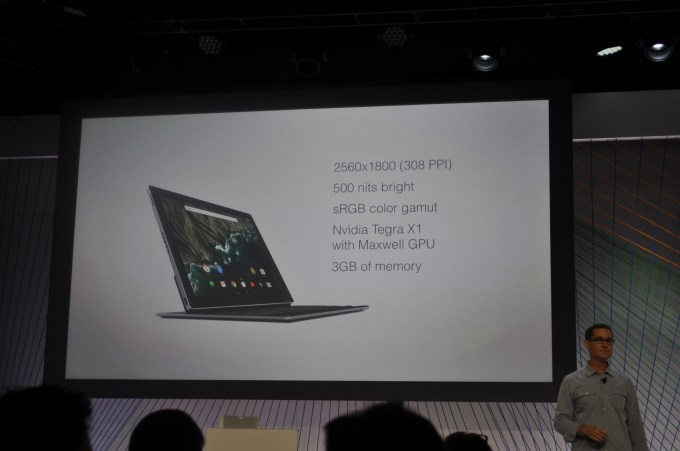
On the specs front, the Pixel C’s high-res display packs in 308ppi — so Google is aiming for the kind of pixel-free viewing Apple touts with its Retina displays — and offers 500 nits on the brightness front. Under the hood there’s an NVIDIA X1 quad-core processor and a “desktop class” Maxwell GPU, and 3GB of RAM. “That’s a lot of graphics horsepower in a mobile device. You’ll see that games really shine,” added Bowers.
Also on board: stereo speakers on either side of the screen, with an eye on the movie viewing experience. And four microphones to power Android voice interactions “from across the room.” It also includes USB Type-C for charging. Battery life was not specifically quantified — beyond Bowers saying it’s “great” for a tablet. He added that Google would be revealing more details about the slate in the coming months ahead of launch.
BY DENIS SLATTERY NEW YORK DAILY NEWS Saturday, September 26, 2015, 6:05 PM
. ROBYN BECK/AFP/GETTY IMAGES This file photo taken on October 8, 2014 shows the moon during a total lunar eclipse. Stargazers will be over the moon Sunday as three separate lunar events converge in one night.
A rare supermoon total lunar eclipse will grace the night sky, coinciding with harvest moon, in a spectacular celestial trifecta that will surely leave astronomers, professionals and amateurs in shared wonder. According to NASA, all three events have lined up just five times since 1900, the last in 1982. And it won’t happen again until 2033. The full eclipse of the moon will last more than an hour and be visible, weather permitting, starting at 10:11 p.m. The phenomenon will unfold as the moon, Earth and sun line up, with Earth’s shadow totally obscuring the moon and casting an eerie red shadow on the lunar surface. Light refracted off of Earth’s atmosphere appears on the moon in a dark-red hue, leading to the term blood moon. The total eclipse coincides with the full moon nearest the fall equinox, which is known as the harvest moon. On top of that, the moon will be at its closest approach to Earth for the year, meaning it’s also a supermoon. And the moon will appear 13% larger to the naked eye, according to NASA. NASA planetary scientist Noah Petro is hoping the celestial event will ignite more interest in our nearest neighbor in space. “The moon’s a dynamic place,” said Petro, the deputy project scientist for the Lunar Reconnaissance Orbiter, or LRO, which has been studying the moon from lunar orbit since 2009. “We’re seeing that it’s not this static dead body in the sky … it’s this great astronomical object that we have in our backyard, essentially. So people should get out and start looking at it.” New Yorkers hoping to witness the rare astronomical event should keep their fingers crossed. The National Weather Service forecast calls for mostly cloudy skies with a 20% chance of precipitation. Tracking Sunday's Supermoon Total Lunar Eclipse 9:07 p.m. - Partial eclipse begins 10:11 p.m. - Total eclipse begins 10:47 p.m. - Mid-eclipse 11:30 p.m. Total eclipse ends Super Moon Facts * Moon will appear 13% larger and 33% brighter than other full moons. * Another supermoon eclipse won't occur until 2033 * The National Weather Service is calling for mostly cloudy skies, with a low temperature around 65 degrees and a 20% chance of precipitation With News Wire Services
Investigators from the National Transportation Safety Board are interested in the front left axle of an amphibious "duck boat" involved in an accident on a Seattle bridge Thursday that killed four college students.
"The front axle was sheared off — for what reason yet we don't yet know," NTSB board member Earl Weener told reporters Saturday, although he said it is too early to determine a cause of the 11:15 a.m. crash on the Aurora Bridge.
The crash killed four international students from North Seattle College who were aboard a charter bus that collided with the 1945 DUKW military-style vehicle owned by Ride the Ducks of Seattle.
Investigators are pictured at the scene of a crash between a Ride the Ducks vehicle and a charter bus on the Aurora Bridge in Seattle, Washington, September 24, 2015. JASON REDMOND / Reuters
The charter bus carrying the students and the duck boat tour vehicle were traveling in opposite directions on the Aurora Bridge when the accident occurred.
A witness behind the duck boat told NBC station KING5 that the duck boat was moving into the left lane when "it seemed to lurch suddenly" before striking another vehicle and then slamming into the bus.
"I saw a bunch of smoke and what appeared to be the front left wheel pop off, and then it clipped a smaller SUV and basically almost T-boned into the oncoming bus and spun around," Jesse Christenson said Thursday.
Federal Investigators on Scene of Deadly Seattle Duck Boat Crash1:51
The amphibious vehicle was refurbished in 2005 for its engine and chassis, Weener said. State officials have said the Ride the Ducks fleet was inspected in 2012, and passed.
Weener said the axle and parts of the drive mechanism would be sent to the NTSB labs in the hope of understanding the characteristics of the fracture and whether it contributed to the crash, or whether it occurred before or after the crash.
"It's way too early to say anything about a probable cause," Weener said.
By Imelda B. Joson and Edwin L. Aguirre Date: 26 September 2015 Time: 08:13 AM ET
This is how the partial phase of the eclipse appears as the umbra glides across the lunar disk. Imelda Joson and Edwin Aguirre obtained this snapshot of the umbra covering roughly half of the moon's surface on October 28, 2004, using an 8-inch f/10 Meade Schmidt-Cassegrain telescope and a Nikon Coolpix 990 digital point-and-shoot camera. The exposure time was 1/500 second at ISO 400. CREDIT: Imelda B. Joson and Edwin L. Aguirre
With the advent of digital cameras, photographing lunar eclipses has never been simpler or easier. Here are some tips on how to capture your own souvenir portraits of one of nature's most colorful and photogenic celestial spectacles.
If you've never recorded a lunar eclipse, you'll get a chance this Sunday (Sept. 27), when the full moon gets totally eclipsed by the Earth's dark shadow core, or umbra. It will be a so-called "supermoon" total lunar eclipse since the moon will be at perigee, its closest point to Earth in its orbit.
To get dramatic close-up views of the eclipsed moon, you'll need a telescope or telephoto lens with a focal length between 500 and 2,000 millimeters. A 300-mm lens or scope will yield a lunar image that's only 3 mm across, just barely large enough to show surface details. You can boost the lens or scope's effective focal length by adding a 2× teleconverter or Barlow lens, respectively.
A telescope with a focal length of 2,000 mm produces a lunar image about 18 mm in diameter, which nearly fills the sensor of a full-frame, 35-mm-format digital single-lens reflex (DSLR) camera. But for many consumer DSLRs that use smaller APS-C sensors, this image size is going to be a bit too large, with the edges of the moon getting cropped in the camera frame. To remedy this, use a focal reducer to make the lunar image fit within the frame, or switch to a telescope with shorter focal length, say, 1,200 mm.
This map shows the areas of the world from which viewers can see the total lunar eclipse. The Americas will have a particularly good view, especially the eastern parts. Credit: Sky & Telescope
Be sure to mount the telescope or telephoto lens on a sturdy tripod for stability and to minimize camera shake, which will blur the images. You can reduce vibrations even further by locking the DSLR's viewfinder mirror up and using an electronic "cable release" to operate the shutter button. A good alternative would be to use the camera's built-in delay timer to open the shutter.
Carefully focus your telescope/camera combination to obtain sharp images of the moon. Many DSLR cameras now offer "live view" mode, which allows you to see what the camera sensor sees, using its built-in LCD screen. You can zoom in on the image up to 10× magnification to check its focus.
Use digital, experiment with exposure
The greatest advantage of digital cameras over film for shooting the eclipse is that you get instant results. You can see what the image exactly looks like by reviewing it on the camera's LCD screen. Does the image look overexposed or out of focus? Not a big deal. Simply adjust the shutter speed or refocus the telescope and try again. Memory cards are now dirt-cheap, so it costs practically nothing to take dozens or even hundreds of photos of the upcoming rare event.
Nobody knows for sure how bright, or how dark, the moon is going to be during totality since it varies significantly from one eclipse to the next. So the best advice would be to "bracket" your exposures, that is, shoot as many images as you can using various exposure settings. Don't be afraid to experiment to find the best combination of aperture, shutter speed and ISO sensitivity for your particular setup.
Remember, the eclipse will start with a dazzlingly bright full moon. The moon then dramatically dims as the eclipse progresses, appearing dimmest around mid-totality. Afterward, it gradually regains its brightness, and the moon becomes full again as the eclipse ends. By taking lots of pictures, you'll increase your chances of catching some really good shots. You can also assemble the series of images to create an animation of the eclipse.
During totality, keep your exposures as short as possible by boosting the camera's ISO setting to 400, or even higher. This will prevent the image from smearing due to Earth's rotation, especially if you are using a fixed tripod. To extend your exposure time to a few seconds and capture the rich red and orange hues of totality, use a motor-driven, polar-aligned equatorial mount to accurately track the moon as it moves across the sky. [Total Lunar Eclipse of Sept. 27: A Complete Skywatching Guide]
Imelda Joson demonstrates how the afocal projection technique is done using an iPhone 6 and the Swarovski spotting scope that she uses for birdwatching. This is the exact setup used to capture the accompanying photo of the first-quarter moon. Credit: Imelda B. Joson and Edwin L. Aguirre
Today's latest generation of smartphone cameras are capable of taking stunning photos of the moon. However, since you can't remove or replace the lens of smartphone cameras, you'll have to use the so-called "afocal projection" method to shoot the eclipse. It sounds intimidating, but it's really not. It simply means you have to aim the phone camera directly into the telescope eyepiece to take the shot. One advantage of afocal photography is that the telescope will greatly increase the effective focal length of the setup so you can capture decent-sized images of the moon even with a smartphone.
Holding the smartphone by hand is the simplest, though not necessarily the easiest way, to aim the camera. The biggest challenge is to hold the phone and try to keep it as steady as you center the moon in the camera frame, focus on the lunar surface and press the shutter button. Since the moon drifts steadily across the telescope's field of view when you're using a stationary tripod, you only have a half minute or so to take the exposure before you'll need to re-adjust the telescope and camera to keep the moon aligned with the eyepiece and camera lens.
For best results, purchase a commercial bracket or adapter from camera retailers or sporting goods stores that sell optics and accessories for hunting or birding (bird-watching enthusiasts call afocal photography "digiscoping"). Alternatively, do-it-yourselfers can make their own custom mounts. Whatever your choice, make sure the bracket or adapter will fit your eyepiece and will hold the smartphone securely. Be sure to focus the telescope visually first before mounting the camera. If you see vignetting, or darkening around the edge of the image, that means the camera is positioned too far from the eyepiece. To reduce vignetting, move the camera as close to the eyepiece as possible while keeping it centered.
Zooming in can also help eliminate vignetting and increase the image size. But don't overdo the zoom function — smartphones generally use "digital zoom" to simply enlarge the camera's picture elements, or pixels, but doesn't improve the image's resolution. You can use the phone camera's autofocus and auto-exposure modes to take the images, or if you prefer, you can adjust the settings to some degree yourself (check the camera manual on how to do this). There are also third-party camera apps you can purchase that will let you control the exposure and edit the photos.
Finally, make sure the smartphone is fully charged since you will be using the LCD screen all the time. Cold temperatures will also cause the battery to lose its charge quickly.
Since the images are stored in your smartphone, you can email, text or share them via social media right away.
Parting shot
The key to imaging the total lunar eclipse is to keep on shooting. If you don't like what you get, make the necessary corrections or adjustments and shoot again. Unlike a total eclipse of the sun, in which totality lasts only a few minutes, or seconds, during this Sunday's total lunar eclipse the moon will be immersed in the Earth's shadow for more than an hour, so you can just keep on trying until you capture a "keeper."
Most important, take a few moments in between exposures to enjoy the eclipse with your naked eye or through binoculars. No photo or video can compare with the real thing, so try to enjoy it visually, too.
Good luck and clear skies!
Editor's note: If you capture an amazing view of Sunday night's total lunar eclipse that you'd like to share for our upcoming column or image gallery, send the images to managing editor Tariq Malik at spacephotos@space.com.
Veteran astrophotographers Imelda Joson and Edwin Aguirre have observed more than a dozen lunar eclipses together since their very first one — a penumbral eclipse on July 27, 1980 — which they viewed from the Philippines. Follow us@Spacedotcom,Facebook andGoogle+. Original article onSpace.com.